An introduction to the temples in the Angkor Archaeological Park, near Siem Reap, Cambodia, for the first-time visitor – historical overview and clarification
By Rick’s Café Noir – 1 October 2025
Many tourists going to Cambodia will visit the temples at Angkor. What they are actually exploring is the Angkor Archaeological Park, designated as a UNESCO World Heritage Site in 1992 – a must-see site for travel photographers and history buffs, and not to be missed.
Cambodia is a popular tourist destination, which has been driven, historically, by the desire to visit the Angkor temples. However, visitor numbers to the Angkor temples in the last few years have actually decreased.
During the Covid pandemic, visitor numbers to the temples, and Cambodia generally, were very low, but since the end of the pandemic, and although international tourist arrivals to Cambodia have increased, the proportion visiting the Angkor temples have decreased.
Much of this decline can be attributed to the disappearance of Chinese visitors, which is bad news for tourism businesses around Siem Reap, but good news for tourists, with less crowding at the popular temples.
Chinese visitor numbers are increasing, though. I read recently that Chinese visitors have increased over 40% this year (2025), compared to last year (2024), admittedly from a low base post-pandemic, but now placing visitors from China third, after Thailand and Vietnam – they used to be first.
This guide is written in three parts; Part 1 is an introduction to the Angkor temples, including a historical overview and some clarification.
Part 2 contains practical advice about visiting the temples.
Part 3 contains advice for photographing the temples, and some useful resources for researching the temples.
Click on the links below to read the contents listed.
Part 1 – use the links below to jump to:
- The Angkor Archaeological Park
- Temple Timeline
- What is Angkor Wat?
- Angkor Face Towers
- Tree Roots Growing Over Stone
- Apsaras or Devatas
- Other Posts on the Angkor Temples
- Camera Gear
- Visiting the Temples
- Ticket Pricing
- Other Posts on the Angkor Temples
Part 3 – general advice for photographers, and resources:
- Advice for Photographers
- The only Temple Guidebook you will need
- Resources
- Last Thoughts
- Other Posts on the Angkor Temples
The Angkor Archaeological Park
The Angkor Archaeological Park covers a large area near Siem Reap town – in the NW Cambodian province of Siem Reap – between the Tonle Sap lake to the south and the Phnom Kulen hills to the north-east.
Incidentally, Siem Reap is pronounced more like “Seem Re-ap” or “Seem Re-ab” by the locals, not “See-em Reep”. In fact, sometimes, the town is named as Siem Reab, with a “b”, on Cambodian government English language maps, eg. the Siem Reab Road Network map for the province of Siem Reab.
The temples at Angkor were founded as earthly, physical representations of Hindu cosmology, and were erected from the 9th century to the beginning of the 15th century by the rulers of the ancient Khmer kingdom.
At its greatest extent, under Jayavarman VII, this kingdom extended from the coast of Vietnam to the borders of Pagan in Burma, and from Vientiane in Laos to much of the Malay peninsula. The boundaries of the empire included present-day Cambodia, most of present-day Thailand (previously Siam), southern Laos, the Mekong delta in southern Vietnam (sometimes temporarily extending into the rest of Champa, home of the Chams), and parts of Myanmar – which is why Angkor temple remains can be found in those locations today.
The balance of power in the region was mostly unstable, and so the borders of the Angkor kingdom fluctuated over the centuries as the expansion of the Khmer kingdom was contested by the Siamese and Chams – hence the many bas-relief battle scenes on the temple walls, particularly at the Angkor Wat and Bayon temples.
The Angkor Archaeological Park contains over 80 temples and monuments built by the Khmer kings who ruled this vast kingdom north of the Tonle Sap lake – including capital cities, and temples and monasteries to house Hindu and Buddhist divinities. So who built these temples and monuments, and when?
Temple Timeline
Temple and monument building in the Angkor period spanned nearly 500 years, and the reigns of 38 kings. Listed below are the Khmer kings responsible for the main, well-known buildings, including the dates of their reigns:
- Yashovarman I (889 – c.915)
- Phnom Bakheng
- Jayavarman IV (921 or 928 – c.941)
- Ko Ker
- Rajendravarman II (944 – 968)
- East Mebon
- Pre Rup
- Banteay Srei
- Jayavarman V (968 – c.1000)
- Ta Keo
- Suryavarman I (1002 – c.1049/1150)
- North Khleang
- South Khleang
- Phimeanakas
- Royal Palace
- Preah Vihear
- Udayadityavarman II (1050 – 1066)
- Baphuon
- West Mebon
- West Baray
- Suryavarman II (1113 – 1145/1150?)
- Angkor Wat
- Thommanon
- Chau Say Tevoda
- Banteay Samre
- Dharanindravarman II (1150? – ?)
- Beng Mealea
- Preah Khan of Kompong Svay
- Jayavarman VII (1181 – 1218/1220?)
- Ta Prohm
- Preah Khan
- Banteay Kdei
- Ta Som
- Neak Pean
- Angkor Thom walls and gates
- Royal Terraces
- Banteay Chhmar
- Bayon
As you can see, Jayavarman VII was very busy, building some of the most popular temples visited by tourists – Ta Prohm, Preah Khan, Banteay Kdei, and the walled city of Angkor Thom (constructed around the earlier Baphuon temple built by Udayadityavarman II), which includes the Bayon temple and the Royal Terraces (The Elephant Terrace and the Terrace of the Leper King). He was the last of the temple builders at Angkor, but his city of Angkor Thom would remain the capital of the Angkor empire for more than 200 years, until 1431/1432.
Other notable kings were Rajendravarman II, who built the superbly detailed temple of Banteay Srei – the first temple in Cambodia to be restored using the anastylosis method of reconstruction – and Suryavarman II, responsible for the construction of Angkor Wat over a period of about 35 years – probably the pinnacle of Hindu temple design and the stonemason’s art in Cambodia.
These temples are old. What remains of Phnom Bakheng, completed in 881, is more than 1100 years old. Banteay Srei is about 1060 years old.
When William of Normandy (aka, the Conqueror) defeated the English king, Harold, at the Battle of Hastings in 1066, the Baphuon was under construction.
Angkor Wat is about 900 years old.
The various temples built by Jayavarman VII are around 800 years old, and were constructed around the same time as Chartres Cathedral in France, which was built mostly between 1194-1220.
All this was achieved with post and beam construction, no use of arches or vaulting – the closest attempts used corbelling to roof passageways. Worth thinking about as you explore.
The empire of Angkor fell after the successful invasion and sacking by the Siamese in 1431, who took over Angkor Wat. Even if the Siamese had not invaded, there is recent tree ring evidence of an extended period of drought, lasting 20 or 30 years, leading up to the 1430s.
So maybe the city would have been abandoned anyway, as the kingdom of Angkor relied heavily on monsoon rainfall, and used an extensive system of canals to move water from the Kulen Hills to the various reservoirs (barays) and moats, allowing irrigation of the flat plains around the city.
This irrigated farmland produced enough food to support a population of around a million people – the largest city in the world at the time.
This food production was essential to maintain a workforce of hundreds of thousands of workers over decades – necessary to build the monuments, excavate the barays and moats, and maintain the canal system. Constant wars would also have depleted the population, making it difficult to maintain this infrastructure.

©2025 Rick Piper Photography. View a hi-res version of this image at rpphotoz.com
The resulting abandonment allowed encroachment by the jungle, causing considerable structural damage to most of the temples. Since construction, seasonal monsoon rains have caused expansion and contraction of the soil under poor temple foundations – in many cases, leading to building collapse. Temple moats helped by providing constant moisture content in the ground under foundations, regardless of the season – avoiding the expansion and contraction of the soil in the wet and dry seasons. Angkor Wat effectively “floats” on a saturated sand substrate all year round.
What is surprising, considering how old they are, is the remarkable condition of many of the temple carvings. Cambodia never had a European-style industrial revolution, so there was no industrial pollution, and therefore no acid rain, which has contributed to the erosion of many historic buildings in Europe.
Sometimes, though, carvings at the temples are very eroded and delaminated – in some cases this could be due to the use of a poorer quality stone, as well as being exposed to the worst of the weather. However, the devata carvings on the 3rd level of Angkor Wat are 900 years old and very exposed to the weather, but some are so sharp they could have been carved yesterday. This is probably due to the use of higher quality stone.

This is certainly the case at the Banteay Srei temple, located north of the main Angkor temple complex, where a very fine, high-grade sandstone was used. The stonemasons here produced some of the most refined and detailed carvings at Angkor, such as the example to the left. Few Angkor temples, other than Angkor Wat, can match this quality.
Some early temples, such as East Mebon and Pre Rup, had stucco (render) applied over brickwork, which was then carved. Generally, this has not weathered well – gone completely at East Mebon, where only brickwork remains, but still evident at Pre Rup.
Many of these buildings have undergone extensive restoration – what you see now is not the condition in which they were found. They are mainly located within the Angkor Archaeological Park, including the most famous – Angkor Wat.

©2025 Rick Piper Photography. View a hi-res version of this image at rpphotoz.com
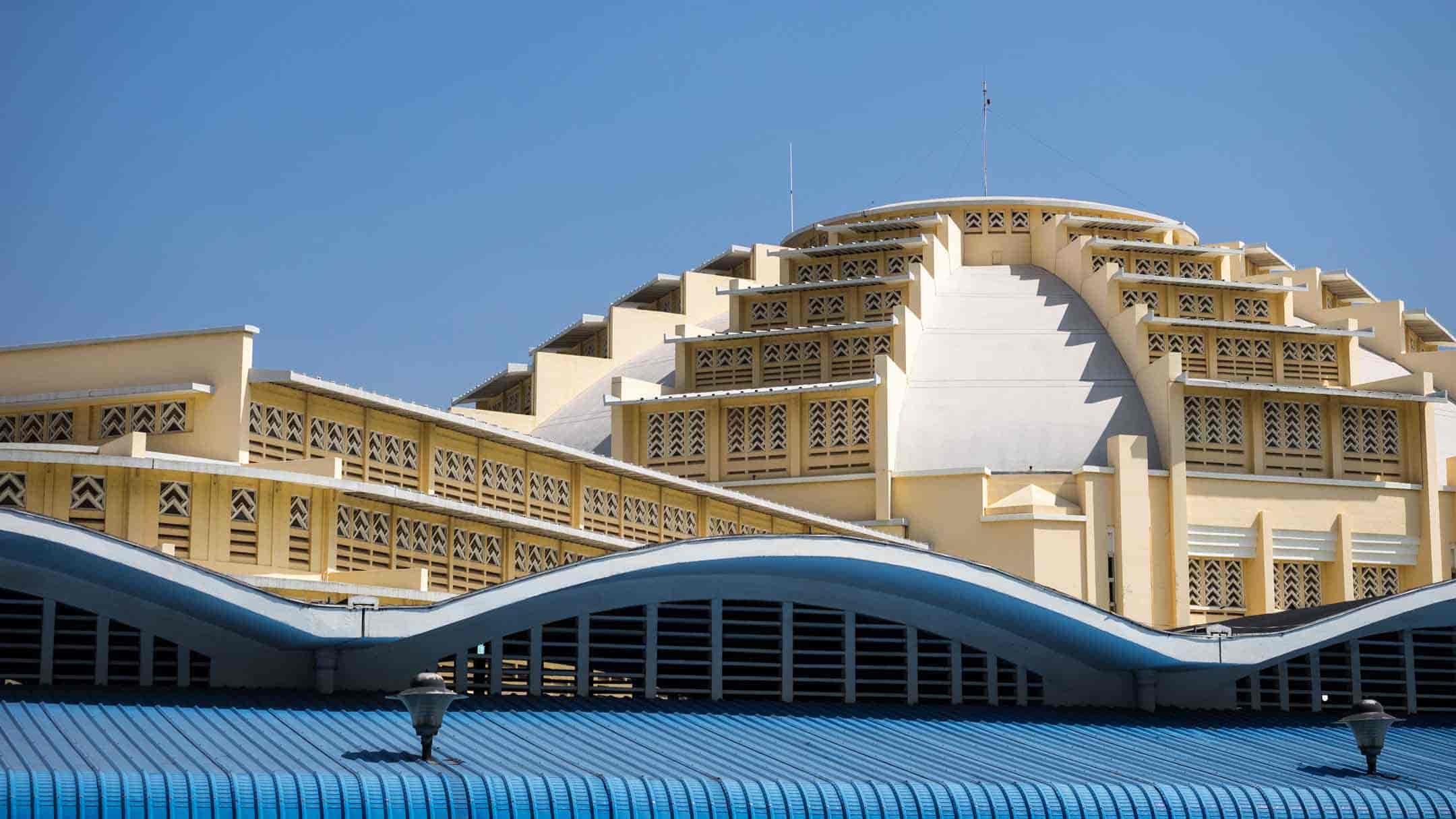
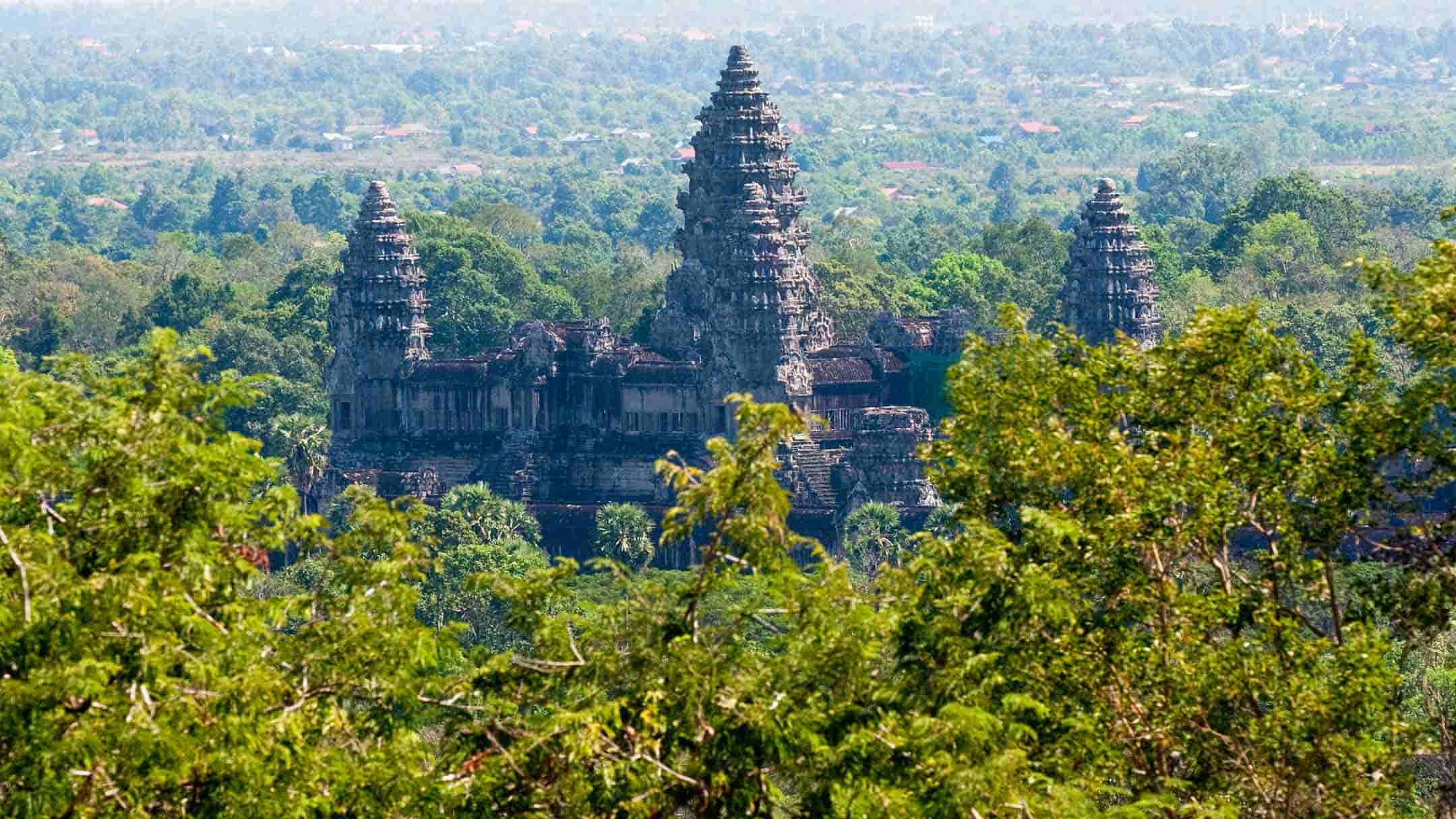
What is Angkor Wat?
First, though – what is, and is not, Angkor Wat? The images above and below are of the Angkor Wat temple.

©2025 Rick Piper Photography. View a hi-res version of this image at rpphotoz.com
On the internet you will find many images of temples from the Angkor Archaeological Park incorrectly identified as “Angkor Wat”. This seems to be a common misconception. Searches in online stock libraries for images of Angkor Wat will sometimes display images from the temples of Ta Prohm, Preah Khan, Ta Som, the Bayon, the gates to the city of Angkor Thom, and others, as well as from Angkor Wat itself. Travel websites occasionally do the same.

Angkor Wat (in the Khmer language, “wat” means temple, and “Angkor” means city, so, the “City Temple”) is just one temple – the largest temple in the Angkor Archaeological Park. In fact, Angkor Wat is considered to be the largest religious structure in the world.
To get the correct names of the temples, check the signboards at the entry to the temples, or use the freely available maps to the Angkor Archaeological Park from many hotels, tourist offices, and travel agents. An Angkor temple guidebook is also useful – more on that in Part 3.

©2025 Rick Piper Photography. View a hi-res version of this image at rpphotoz.com
Angkor Face Towers
Images of face towers, often labelled as “Angkor Wat”, are incorrect. There are no face towers at the Angkor Wat temple.

The nearby ancient walled city of Angkor Thom has face towers, on its five, arched entry gates. The South Gate, North Gate, and Victory Gate are the most used, with paved roads running through them. The South gate is the usual entry gate for visitors arriving from Siem Reap and the Angkor Wat temple. The North gate is the exit gate to Preah Khan and the temples on the Grand Tour Route. The Victory Gate is the exit gate to Ta Prohm and the temples on the Small Tour Route. The West Gate leads to farmland, and is a back route to get to the Angkor Wat parking, market stalls, and restaurant area.
The East Gate, accessed by a dirt road, leads into the surrounding forest – hardly anyone visits it. The best way to see the gates up-close is to walk the path along the top of the city walls, eight metres above the moat.

©2025 Rick Piper Photography. View a hi-res version of this image at rpphotoz.com
You can get “Face in the Forest” shots, like the one below, and the chances are, you will be the only one there.

©2025 Rick Piper Photography. View a hi-res version of this image at rpphotoz.com

©2025 Rick Piper Photography. View a hi-res version of this image at rpphotoz.com

©2025 Rick Piper Photography. View a hi-res version of this image at rpphotoz.com

©2025 Rick Piper Photography. View a hi-res version of this image at rpphotoz.com
At the centre of Angkor Thom is the Bayon temple, famous for its many face towers, carved with enigmatic, giant stone faces, shown in the two images above.
In addition to the face towers at the Bayon temple and the Angkor Thom entry gates, there are face towers at other temples, usually on the main entry gates in the outer enclosure walls – such as at Ta Prohm, Banteay Kdei, Ta Som, and Banteay Chhmar.
The image at left is a face on the eastern entry face tower at Banteay Kdei Temple, just across the road from Srah Srang.
Tree Roots Growing Over Stone

Some of the Angkor temples have tree roots growing over the stonework. Images of tree roots growing over ruins labelled as “Angkor Wat” are also incorrect. No tree roots grow over the stonework of Angkor Wat.
The “discovery” of Angkor Wat is usually credited to the French naturalist Henri Mouhot, who visited in 1860. The notes of his visit were published in 1864, after his death in 1861. However, he was not the first European to see Angkor Wat. Other Europeans published accounts of their trips as early as 1855, but they received little recognition in the west.
At that time, Angkor Wat temple was surrounded by jungle vegetation growing next to the building, which was cleared. As the temple had been in continuous use since the collapse of the Angkorean empire, no trees had taken over the building as they did in many of the other temples, which had been left to decay, collapse, and disappear into the jungle.
Temples with tree roots growing over stonework can be found at Ta Prohm, Banteay Kdei, Preah Khan, and Ta Som.

©2025 Rick Piper Photography. View a hi-res version of this image at rpphotoz.com

©2025 Rick Piper Photography. View a hi-res version of this image at rpphotoz.com

©2025 Rick Piper Photography. View a hi-res version of this image at rpphotoz.com
When researching information about the Angkor Wat temple it can be very confusing (and frustrating) to find images labelled as “Angkor Wat” that are not actually Angkor Wat. All the temples on this website are correctly named, as are the images on my photo websites.
Apsaras or Devatas?
There seem to be some differences of opinion concerning Apsaras. There are beautiful carvings of ladies everywhere at Angkor, a few thousand of them, but are they all apsaras?
In Hindu mythology, apsaras are the celestial nymphs born of the “Churning of the Ocean of Milk” (see the bas-reliefs at Angkor Wat), whereas devatas are semi-divine beings who guard the sanctuaries devoted to divinities.
People often refer to them both as apsaras, as do some guidebooks, but apsaras and devatas are different. I’ll keep to the classical distinction between apsaras and devatas – apsaras dance, devatas stand. Easy to remember.
You can buy photo books on apsaras, and there are thousands (millions?) of apsara images on the internet, but a lot of them should really be called devatas.
Apsaras are always shown flying through the air, or dancing, sometimes on a lotus pad.

©2025 Rick Piper Photography. View a hi-res version of this image at rpphotoz.com

©2025 Rick Piper Photography. View a hi-res version of this image at rpphotoz.com
Devatas are always shown standing, often holding a lotus flower, but sometimes holding a mirror, or a book, or linking arms with other devatas in groups as large as five ladies. They often have elaborate hair-styles, tiara-style headdresses, and jewellery. Some even have teeth! Sometimes they smile, but they do not dance!

©2025 Rick Piper Photography. View a hi-res version of this image at rpphotoz.com
Other Posts on the Angkor Temples
This post, Part 1, is a general introduction to Angkor, mainly a historical overview and some clarification.
Part 2 contains practical advice for visiting the temples.
Part 3 contains general photographic advice and some useful resources for researching the temples, including a list of other posts in this series that will address individual temples, listed below, with tips for getting the most out of your visit photographically.
These blog posts, based on my experiences, may help you get some great images. If there is a hyperlink in the list below, I have published the post. I hope you will be inspired!
- Angkor Thom – Ancient Khmer City
- Angkor Thom – Elephant Terrace
- Angkor Thom – Royal Palace Compound & Phimeanakas Temple
- Angkor Thom – Suor Prat, the Khleangs, and Preah Pitu
- Angkor Thom – Terrace of the Leper King
- Angkor Wat – Introduction
- Angkor Wat – Sunrise and Sunset
- Angkor Wat – Western Gate
- Angkor Wat – Eastern Gate
- Angkor Wat – Cruciform Galleries
- Angkor Wat – 2nd Level
- Angkor Wat – 3rd Level
- Banteay Kdei
- Banteay Samre
- Banteay Srei
- Baphuon
- Bayon – Face Towers
- Bayon – Bas-reliefs
- Bayon – Devatas and Apsaras
- Face Towers at the Angkor Temples
- Preah Khan – Eastern Entry
- Preah Khan – Hall of Dancers
- Preah Khan – Central Courtyards
- Preah Khan – Western Entry
- Ta Prohm
- Ta Prohm – Tree Roots
- Tree Roots at the Angkor Temples
Camera Gear
All images in this post were shot either:
- Using Fuji Sensia transparency film in Olympus OM1 cameras, with Zuiko lenses – transparencies were then scanned using a Nikon ED5000 film scanner and processed in Photoshop
- Or, shot in RAW using digital Nikon camera bodies, with Nikkor Pro f2.8 lenses, and then processed in Lightroom and Photoshop.
- Or, shot in RAW using digital Olympus OMD camera bodies, with Zuiko PRO f2.8 lenses, and then processed in Lightroom and Photoshop.
All images Copyright ©2025 Rick Piper Photography (unless noted otherwise). All rights reserved.